Temporal changes in deposition status of radiocesium in terrestrial environments

Interviewee
Kotaro Ochi
Research purpose and contents
Following the accident at TEPCO Fukushima Daiichi Nuclear Power Station (FDNPS), the impact on human health in the disaster area was assessed using exposure doses as an index (Sv). Exposure doses of the subjects were primarily evaluated directly using a pocket dosimeter, and an evaluation was performed based on the air dose rate measured using a survey meter. The air dose rate varied greatly depending on the quantity, type, and distribution of radionuclide deposited on the surface ground, as well as the condition of the ground surface. As a result, temporary air dose rate information is insufficient to accurately estimate the exposure doses. The focus was on the radiocesium (134Cs and 137Cs) on terrestrial environment, which has a long half-life and radiation derived from radiocesium has been contributed to dose exposure. The deposition status of radiocesium has been evaluated in three major areas (farms, forests, and cities) to assess the dose exposure status of residents. An unmanned helicopter mounting a radiation detector was used in farms to verify the technology for observing the deposition status of radiocesium over a wide area rapidly and easily. In urban areas, monitoring of change in trends of deposition status of radiocesium has been performed on an ongoing basis 1-2 times a year since 2011.
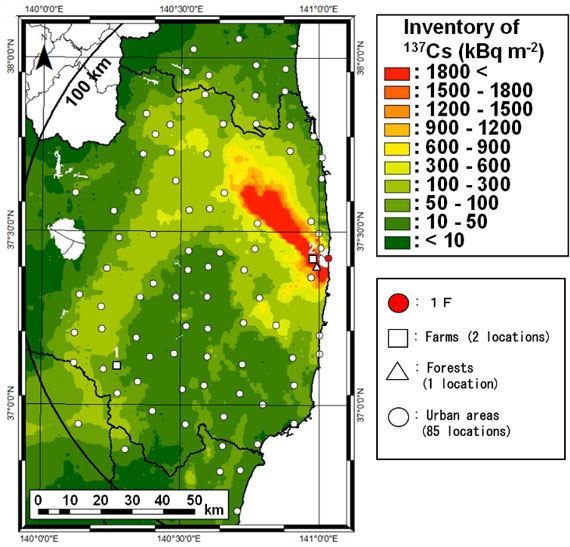 Location of survey points on a 137Cs deposition density map
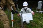
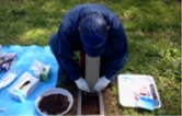
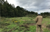
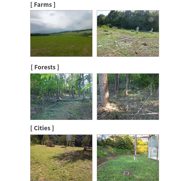 Image of each survey point
Relationship between the deposition density of radiocesium and air dose rate.
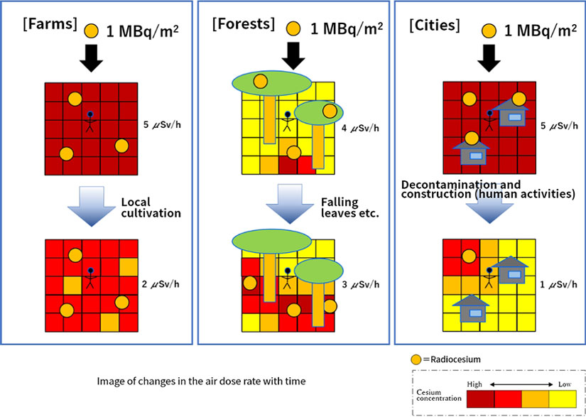
Although the deposition density of radiocesium is expressed by an index known as activity per unit area (Bq/㎡), even with the same deposition quantity, the air dose rate at 1 m above ground level may vary significantly depending on the vertical distribution of radiocesium in soil. Further, even if the deposition density of radiocesium (for example, 1 MBq/㎡) is the same, the tendency to change the distribution of radiocesium may vary depending on the state of the ground surface. For example, local cultivation work in farms, the capture of radiocesium in tree canopies (areas where branches and leaves grow thick) and falling leaves in forests, and human activities, such as decontamination and construction in urban areas, may have an impact on changing trends in air dose rates. This implies that the exposure doses will vary in each respective environment. Therefore, we have to appropriately evaluated the deposition status of radiocesium in the soil in areas where residents live (farms, forests, and cities).
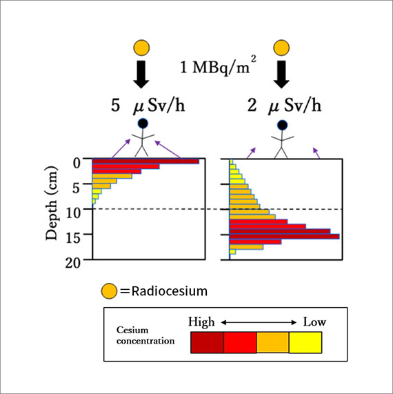 Image of air dose rate based on vertical distribution of radiocesium
Development of measurement technology using an unmanned helicopter
As a method of surveying the deposition status of radiocesium in soil, the typical method was
used to manually sample the soil cylindrically and measure the activity concentration of radiocesium in
each layer. This method can evaluate the deposition density and vertical distribution of radiocesium
accurately; however, as the sampling and analysis work are troublesome, there is a disadvantage that a
lot of time is required to deliver the results.
As an original method for Fukushima, technology was
developed to estimate the vertical distribution of radiocesium in the soil based on the γ-ray spectrum
characteristics that could be acquired aerially.
Typical method
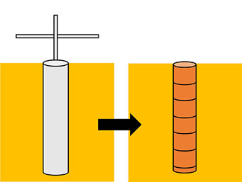
Typical soil sampling method
Fukushima original method
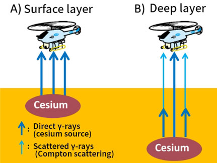
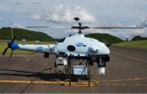
Method of observation using an unmanned helicopter
Using this method, the vertical distribution of radiocesium over a wide range can be measured
more rapidly and easily than with typical methods.
However, it is difficult to judge the impact of
local soil disturbance via measurement technology using unmanned helicopters. Therefore, it is
considered to achieve highly efficient and accurate monitoring by combining new and typical methods.
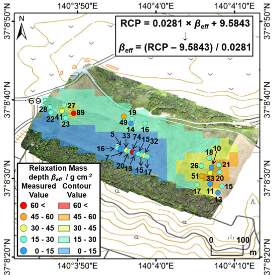
RCP(Compton-to-peak ratio):Ratio of scattered γ-ray counting rate/direct γ-ray counting rate on the γ-ray spectrum obtained by unmanned helicopter measurement.
βeff:Parameter expressing radiocesium vertical distribution. The larger the number, the deeper the radiocesium distribute in
Vertical distribution map of radiocesium estimated based on the result obtained by aerial monitoring using an unmanned helicopter
Contribution to the restart of farming and life through effective monitoring
It is extremely difficult to remove all of the radiocesium that has fallen on the surface ground
over a wide range. However, by estimating the vertical distribution of radiocesium in the soil
using an unmanned helicopter, a vertical distribution map for radiocesium can be created, and
the depth of decontamination can be effectively determined, promising a path towards the restart
of farming in the area.
In the urban areas where many residents live, it is essential to
accurately measure the air dose rate to assess the exposure doses. Therefore, it is crucial to
monitor the deposition status of radiocesium over the medium to long term. We would like to
pursue research to allow residents to live with greater safety and peace of mind through more
accurate assessments and predictions.
Related information
| Researcher | Kotaro Ochi(researchmap) |
|---|
| References | Public link to 137Cs initial deposition density map:http://www.ied.tsukuba.ac.jp/~fukushimafallout/ Vertical distribution map of radiocesium:K. Ochi, M. Sasaki, M. Ishida, S. Hamamoto, T. Nishimura and Y. Sanada, Estimation of the Vertical Distribution of Radiocesium in Soil on the Basis of the Characteristics of Gamma-Ray Spectra Obtained via Aerial Radiation Monitoring Using an Unmanned Helicopter, Int. J. Environ. Res. Publ. Health, 14, 926_1-926_14 (2017). |
|---|