Development of nuclear power disaster prevention tools (terrestrial)

Interviewee
Miyuki Sasaki
Research purpose and contents
When measuring radiation in Japan, after the accident at the TEPCO Fukushima Daiichi Nuclear Power Station (hereafter "FDNPS"), research and development (R&D) into "aspects" over a wide area based on the measurement of "hot spots," i.e., "points" has become essential. Radiation monitoring after the FDNPS accident has involved surveys using "manned helicopters," "unmanned helicopters," "vehicles," and "walking," and the results are essential data that will become foundational material for setting evacuation order zones and determining the scope of decontamination.
At the time of the FDNPS accident, due to the impact of tsunami and power loss, radiation monitoring devices within the premises and surrounding areas were not functioning, which caused problems for sharing information. Thus, the Nuclear Regulatory Commission set the "measures to prevent nuclear emergency" and created a disaster prevention scheme. To realize this scheme, we have been newly developing a "radiation measurement system" to enable the smooth and rapid performance of a series of tasks from monitoring measurement to analysis and decision-making.
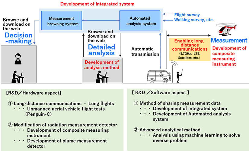
Overview of a radiation measurement system under development
Measuring radiation using unmanned planes
We are conducting flight tests for measuring radiation, using unmanned flight systems as an emergency monitoring tool. We aim to achieve long-distance communications/long flights using 5.7 GHz band, LTE, and satellite communications. Unmanned flights use a waterproof system while flying during rain, etc.; they can be loaded into a mini-van when transported using a dedicated transport case, allowing the equipment to be easily taken to the site. In terms of the equipment to be loaded on the vehicle, we are promoting the development of compound measurement devices and plume measuring devices capable of capturing various information in one go. In the future, it is considered that these technologies can reduce the contamination of employees and enable safe and rapid measurement across a wide area.
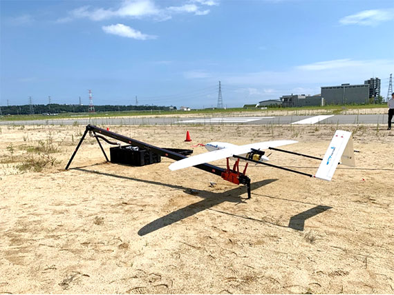 Unmanned aerial vehicle under testing
Increased accuracy in radiation measurement values was captured from the sky.
As far as measurement results from the sky are concerned, it is possible to calculate the air dose values with greater accuracy than before by "machine learning" through calculating a large number of measurement empirical values using statistically-obtained parameters. Using this method, we can obtain a map with a high consistency of air dose rate of 1 m above ground, and radiation measurement results are safe and accurate using unmanned devices. To move forward, we aim to develop a method of evaluating and mapping the reliability of these calculation results.
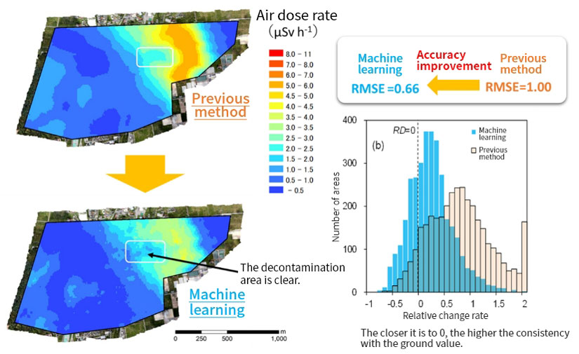
Advanced radiation measurement using machine learning
Leaving a rapid and safe method of measurement and analysis for future generations.
In case a nuclear power station accident occurs again, the aim is to establish measurement analysis method technology that will allow rapid and safe radiation monitoring to happen; it can be used as individual systems (radiation measurement system) that can integrate and combine data for future generations.
Moving forward, we will continue to promote R&D on value analysis of radiation measurement technology that can be used in all areas, including not only on land but also at sea and atmosphere, and applied to other fields, such as space and medicine, which have a close relationship with radiation.
Related information
| Researcher | Miyuki Sasaki(researchmap) |
|---|
| References | Journal name:Scientific Reports Thesis title: “New method for visualizing the dose rate distribution around the Fukushima Daiichi Nuclear Power Plant using artificial neural networks” Author name:Miyuki Sasaki、Yukihisa Sanada、Estiner W. Katengeza、Akio Yamamoto |
|---|